|
Lake Sounding Data Project Man has always been intrigued by the depths of natural lakes. Before modern surveying methods were able to accurately measure these depths, they were the source of fanciful stories and local legend. Ancient cultures often considered deep lakes to be portals into the worlds of the Gods. Countless lakes with clear blue waters were deemed bottomless. Some were even thought to have underground connections to the oceans. The truely deep lakes often spawned stories of large unknown creatures swimming in their depths. 
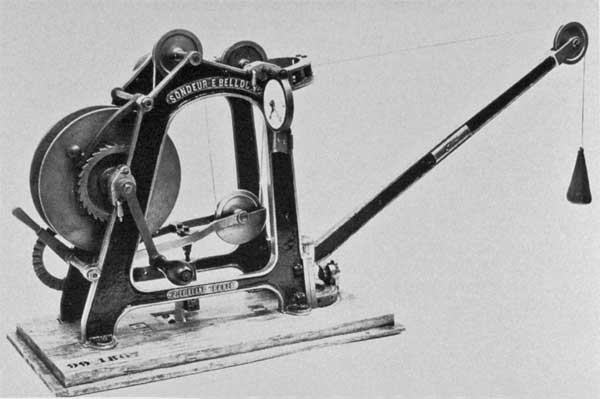
Sounding device of Emile Belloc Lakes remained a source of wonder and legend until scientists began to systematically sound their depths. Early depth measurements from lakes Baikal, Ladoga and Geneva proved that even the largest lakes indeed had bottoms. In the early 19th century, surveyors from England, Germany, and Austria began dispelling the myths of bottomless lakes in the mountainous regions of their countries. By the 1850's, geographers and cartographers from all over Europe had begun to sound many of the continent's larger lakes. But it wasn't until Forel's seminal work on limnology appeared in the late 1890's that scientists began measuring the depth of lakes on a large scale. During this period entire atlases of bathymetric maps were produced for the lakes of France, Austria and the German Alps. Similar publications would follow for Italy, the Balkan Peninsula and the Tatra Mountains. In the early 20th century, Wilhem Halbfass published the first catalog of sounded lakes. In it, he included all surveyed lakes of Europe having surface areas greater than a square kilometer. This work was the precursor to the much larger publication in 1922 of "Die Seen der Erde." This comprehensive catalog of world lakes presented a vast amount of bathymetric data. Early surveying efforts proved time-consuming, since manual soundings were taken with a weighted line often in row boats. Survey methods gradually became more accurate as wire lines and surveying equipment helped reduce error in both depth and positional measurements. With the invention of sonar in the 1920's, bathymetric surveys could be performed more quickly and with more detail. As a result of this new technology, the amount of lakes with accurate bathymetries greatly increased. In North America, governmental agencies began comprehensive mapping programs to systematically sound lakes primarily in relation to fisheries studies. Similar programs were started in Europe as well. Today, most large lakes have bathymetries that are well known and accurately mapped. |
![]()
© MapGraphica. All rights reserved.